
The One Country Google Maps Will Not Route You Through: Inside Korea’s 18-Year Map Standoff
The list of places where Google Maps will not give you a driving route is short, and once you take out the uninhabited islands and a military base, one country is left on it. North Korea is not on that list. The eighteen-year fight behind this ended last winter, and the routing still has not switched on.

Your phone is not broken
You land at Incheon, clear immigration, find the train, Map and somewhere around the moment you need to get from the station to your hotel you open Google Maps. The map loads. Your hotel is there. Restaurants are there, with photos and star ratings and opening hours.
Then you tap directions, and nothing useful happens. No driving route. No walking route. Just a map that knows exactly where you are and refuses to tell you how to leave.
Most people assume something is wrong on their end. They toggle airplane mode. They reconnect to the airport wifi. They delete the app and install it again, which takes a while on airport wifi and changes nothing.
The phone is fine. The app is fine. You have walked into the tail end of an argument that has been running since before the first iPhone, and the strangest part is that the argument was settled earlier this year and the maps still do not work.
The clearest place to start is a page Google publishes about itself.

The list Google keeps about its own maps
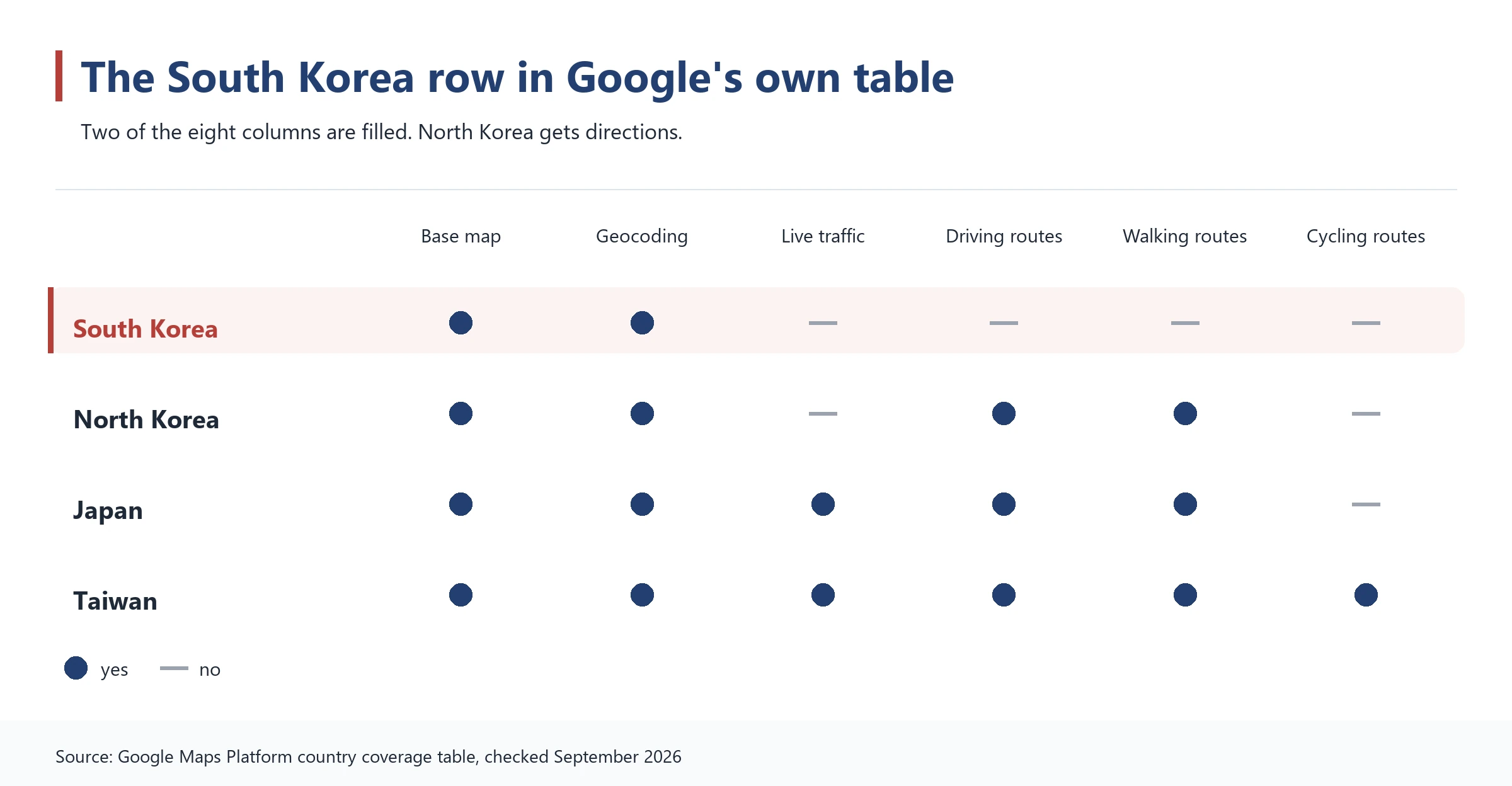
Google publishes a support table for developers showing which mapping features work in which country. One column is driving directions. Another is walking directions. Another is live traffic. Every country and territory on earth gets a row, and every row gets a mark or a dash.
Almost every row has the mark. Driving directions work essentially everywhere. The places where they do not can be counted on one hand and a couple of fingers.
Who else is on that list
Open the exceptions one by one and they turn out to be mostly empty. An island near Antarctica with no permanent residents. A military base in the middle of the Indian Ocean. A pair of specks in the South Atlantic where a few hundred people live. Two Spanish territories appear as separate rows, but Spain itself is marked, so those are a filing quirk rather than a hole in the map.
Strip out the uninhabited rocks and the military base and one country is left standing there. South Korea.
North Korea works
This is the part that usually makes people go back and check the page themselves. In the same table, North Korea has driving directions and walking directions. So does Iran. So does Syria. So does Cuba, and Afghanistan, and Russia.
Whatever is happening in South Korea, it is not sanctions and it is not a shortage of roads. The country has some of the best mapped, best maintained, most photographed road network anywhere. The reason is not coming from outside. It is domestic, it is legal, and it is about one specific map.
The map nobody is allowed to take out of the country
South Korea restricts sending detailed national survey data abroad. The law is dry and the reasoning is not: the country is still technically at war, the border is a couple of hours from Seoul by car, Map and a very precise map of every road, bridge and building is also a very precise map of every military installation on it.
Not every map is locked up. A coarser one can be used freely by anyone, and Apple built its Korean service on exactly that. The trouble is what a coarser map can and cannot do. Map
Why the scale matters so much
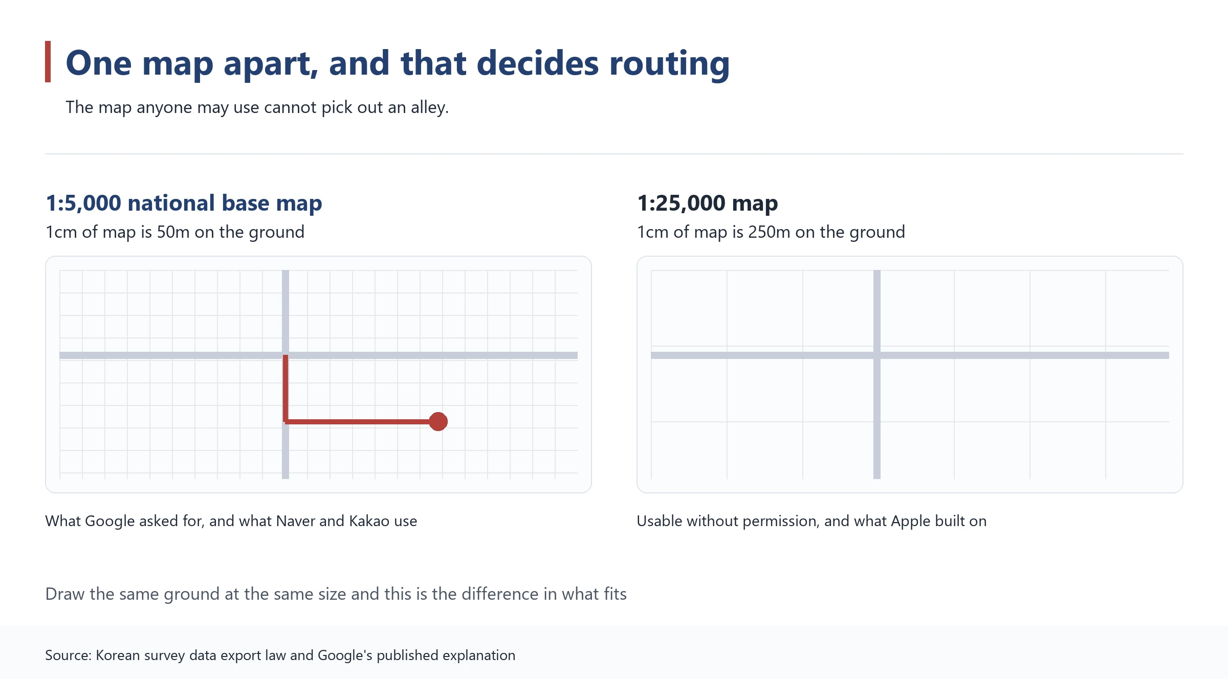
The map Google wants is drawn at 1:5,000. The one available without permission is 1:25,000. On the second, a single centimetre of map covers a quarter of a kilometre of city.
Google has argued for years that this is simply not enough to tell you which alley to turn down in a place like Myeongdong. Map It is fine for showing you roughly where a neighbourhood is. It is useless for saying “turn right after the convenience store”.
The government side is not flimsy either. That 1:5,000 map took decades and more than a trillion won of public money to build. And there is a subtler worry: lay it over the satellite imagery Google already owns and features that were deliberately left off one may become obvious on the other.
So the fight hardened into a yes-or-no question about handing over a file, and stayed there for eighteen years.


Three requests, three different endings
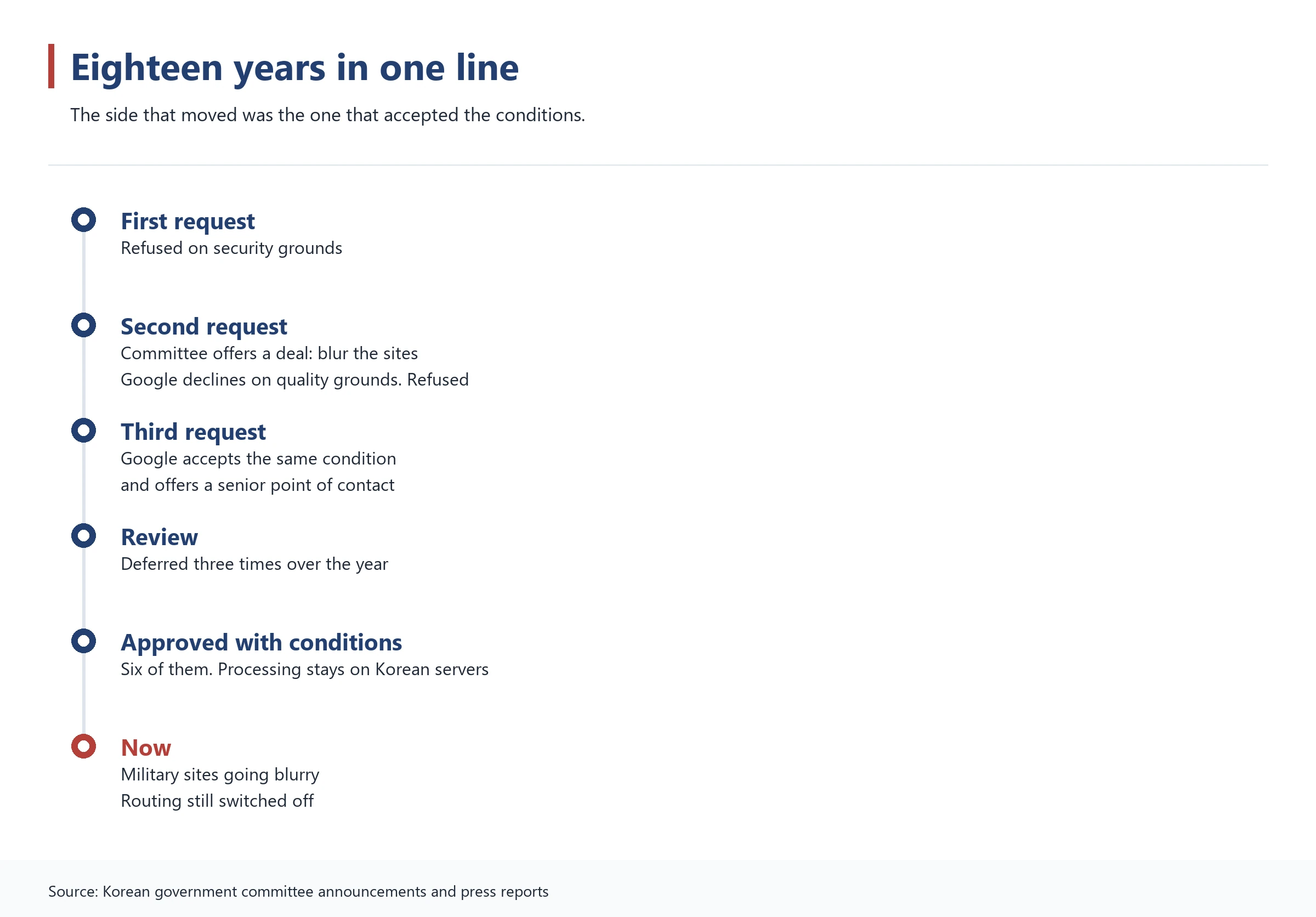
Google first asked in 2007, back when maps on phones were a novelty. The answer was no, on security grounds.
These requests are not decided by one official. There is a standing committee for exactly this, chaired by the national geographic information institute, with the defence ministry, the foreign ministry, the interior ministry and the intelligence service around the table.
It does not meet often. Counting every request from every foreign company since the committee started working properly gets you to roughly ten. Google has knocked more times than anyone.
2016 is where this story turns
On the second attempt the committee did not simply refuse. It offered a deal: blur the security sites, and the data can go.
Google said no. The reason it gave was service quality. Blurring Korean sites would mean a visibly degraded patch on a global product, and Google did not want smeared pixels sitting in the middle of its own map. The committee met one last time and refused the export.
Hold on to that, because it is the hinge. The condition Google turned down in 2016 is the same condition that eventually got it what it wanted.
The side that blinked was Google
The third application arrived in early 2025, and the tone of it had changed completely.
This time Google said it would blur security facilities when the government asked. That is the condition it had rejected on quality grounds nine years earlier. It also offered to appoint a senior executive as a permanent point of contact with the Korean government.
The committee still did not rush. It met in spring, again in summer, again in late autumn, and deferred all three times. Security was only one of the things on the table. There was trade pressure from Washington on one side and a domestic mapping industry on the other.
Then, in February, it said yes
The committee reviewed a supplementary filing and approved the export, with conditions. Eighteen years and three attempts after the first request, the door opened.
It is easy to read that as the government giving in. Look at the conditions and it reads the other way round. They point in the same direction as the offer Google walked away from in 2016. What changed was Google deciding to accept them.
Six conditions, and one of them is heavy
Approval did not mean handing over a file. Six conditions came attached, and reading them explains why your phone still cannot route you anywhere.
Satellite and aerial imagery of Korean territory shown anywhere in the world has to be the security-processed version. Historical imagery and street-level photography have to carry the same masking. Coordinate readouts for Korean territory are restricted.
The map has to be processed on Korean soil
Map processing may only happen on domestic servers run by a domestic company. The raw data goes to a Korean partner, gets processed there, and only what the government has reviewed and approved leaves the country.
That condition runs straight into Google’s own long-standing argument. Google has said repeatedly that it needs to spread the work across data centres worldwide to serve billions of people at once. Korean map data is now pinned to servers in Korea.
The last condition is quietly telling. Google has to station what the paperwork calls a Local Responsible Officer inside the country. When a military site is built or moved, the government wants someone to call, and that someone has to be sitting in Seoul.
The Blue House went blurry for the first time in 21 years
Compliance became visible in early September, and you can see it yourself right now. Open Google Earth and look at the old presidential compound in central Seoul. Map It is a smear.
So is the intelligence service. So are the defence ministry and joint chiefs buildings in Yongsan. So is the nuclear research institute, the THAAD battery at Seongju, and the American bases at Pyeongtaek and Osan. Korean air force fields and jointly used airfields have gone soft, and so have a few points just north of the military demarcation line.
The Blue House had been sitting there in plain view for 21 years. You could count the roof tiles.
Coordinates disappeared too
Around the same time, something quieter changed. Open Google Maps on a Korean connection and point at a spot, and the latitude and longitude no longer appear. On Google Earth they still do.
The blurring spreads as imagery updates, so it is not finished. And nobody announced when it began. Neither Google nor the government published a start date. People simply noticed their screens had changed, and a report in early September put it on the record.

So why is there still no route on your screen
At this point the obvious thought is that the approval landed, the blurring started, and directions must be back.
They are not. Driving and walking routes still do not appear. Live traffic does not appear. Speed limits do not appear. That public table of Google’s, the one with the dashes, still has South Korea marked the old way.
Permission is one job and rebuilding a service is another. The processing pipeline has to be stood up on a Korean partner’s servers, the government approval loop has to run, and only then does anything switch on.
Whose map are you actually looking at
Which raises a good question. If Google has no routing here, how is there a map on your screen at all?
Google answered this itself, in writing. The base map you see in Korea is licensed from T map, the navigation arm of the country’s largest mobile carrier, and it is drawn at 1:5,000. Google described what it currently offers in Korea as a plain map display service with no routing.
So the Korean map inside Google Maps was made by a Korean company. Google has been putting its own business listings and reviews on top of somebody else’s map the whole time.
If Naver can do it, why not Google
The obvious objection writes itself, and Google has made it. Naver and Kakao build turn-by-turn navigation on the same 1:5,000 data. Why can they use it when Google cannot?
The government answer is that using the map and exporting the map are different acts. Korean companies keep that data on Korean servers, inside Korean jurisdiction. Once it sits on servers abroad, none of those levers work any more.
There is a commercial argument underneath the security one
The domestic industry has a different worry, and it is not about the military. A fully working Google Maps in Korea would be a serious competitor overnight in a market two local companies currently share. Maps are not a standalone product. They feed search, advertising, delivery logistics and eventually self-driving cars.
Reaction to the approval split along exactly that line. One camp welcomed it as an overdue fix for foreign visitors. The other worried about handing another layer of daily life to a company headquartered elsewhere. Neither has been proved right yet, because the feature is not on.
Meanwhile a queue has formed. Apple, Microsoft and carmakers have all been reported as circling the same door now that someone has finally opened it.
Apple Maps is broken in a different way
If you use an iPhone you may be wondering whether Apple Maps escapes all this. Partly. Apple built its Korean service on the coarser map that needs no permission at all.
So driving directions do appear in Apple Maps here. Whether they are useful is another matter. Apple has no live traffic feed for Korea, so it routes you as though every road in Seoul is clear, which is a bold assumption at six in the evening.
Walking directions are simply switched off. Ask for a pedestrian route and you get a message saying it is unavailable in this area.
Apple has not even applied
Google got its approval in February. Six months later Apple still had not filed the supplementary request that would start the same process for its own maps. The door is open and Apple has not walked through it.
The practical upshot: switching phones does not solve your problem. Neither of the big international map apps will get you across Seoul.
When does it actually turn on
Google is reported to be aiming for the first quarter of next year to launch driving and walking navigation here, bundled with AI place recommendations and route planning.
Treat that as an aim rather than a date. This story has slipped before. The approval itself was deferred three times, and the blurring that was supposed to demonstrate compliance only became visible half a year after the decision.
You can check without waiting for the news
If you want to know the moment it changes, go back to that country support table Google publishes and look at the South Korea row. When the driving directions column fills in, it is live. The table moves before the headlines do.
And when it does fill in, South Korea comes off a very odd list: the one it currently shares with an Antarctic island, a naval base and a few hundred people in the South Atlantic.
What to do on your trip, starting now
Until that column fills in, you need a Korean map app, and the single most useful thing you can do is install it before you fly. Downloading an app on airport wifi while jet-lagged and holding a suitcase is a miserable way to start a holiday.
There are two worth having, and we have compared them properly in our guide to Naver Map and Kakao Map, including how to switch each one into English. Both are free, both work without a Korean phone number, and between them they cover searching, walking, buses, subways and taxis.
If you only want one, take the one with the stronger place search. If you are going to use taxis or drive, take both. The rest of what is worth installing before you land is in our Korea travel apps guide.
Keep Google Maps anyway
Everything except routing still works, and that is more useful than it sounds. Search for places, read reviews, check opening hours, look at photos, and save pins for everywhere you want to go.
The move most travellers settle into is planning in Google Maps and moving in a Korean app. Build your pin list before the trip, then copy the place name into Naver Map when you actually want to get there. Korean place names usually match.
This matters most if you are driving. Picking up a rental car on Jeju with only Google Maps on your phone means getting stuck at the first junction, and the car’s built-in navigation is often Korean-only.
One last thing that catches people out: every one of these apps needs data to work. Sort out a SIM or eSIM before you arrive rather than after, and the first hour in the country gets a great deal easier.

🎡Things to Do74
🍜Food8
🏨Where to Stay4
🚇Getting Around14
🧭Travel Tips25
📌More3
Common questions
See the full Korea travel guide
Images: Photographs via Wikimedia Commons: Christian Bolz (CC BY-SA 4.0), Dwxn (CC BY-SA 4.0), lumoplank (CC0), kallerna (CC BY-SA 4.0), Jhcbs1019 (CC BY-SA 4.0), AirportTerminalGuy (CC BY 4.0). Charts by Breeze Korea from the Google Maps Platform coverage table and Korean government announcements.